




Kenya Weather Alert: Rain, Strong Winds and Rising Temperatures Expected This Week — Here’s What to Expect
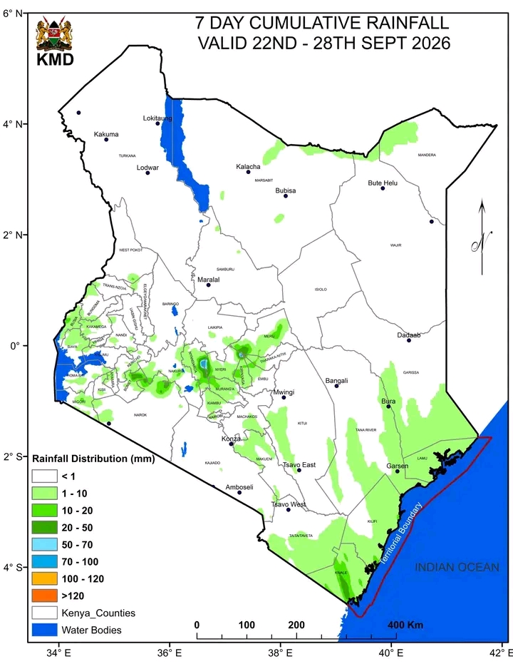
Kenya is expected to experience mixed weather conditions this week, from September 22 to September 28, 2026. Western Kenya, parts of the Rift Valley, the Lake Victoria Basin and sections of Central Kenya are among the areas where rainfall is expected, with Kakamega, Vihiga and Bungoma highlighted for enhanced rainfall in today's forecast. At the same time, northern and northeastern counties are expected to experience hotter conditions, while strong winds could affect several northern and coastal areas. Nairobi and parts of Central Kenya may experience relatively cool conditions with chances of rainfall. The forecast is important not only for ordinary daily activities but also for farmers, motorists, businesses, schools, construction workers, fishermen and communities living in areas vulnerable to weather-related hazards. Kenyans are encouraged to remain alert, plan according to their local conditions and continue following updates from the Kenya Meteorological Department, especially when severe weather is forecast.
The Kenya Meteorological Department (KMD) has continued to issue updated weather information as the country enters the final part of September, with conditions expected to vary considerably from one region to another during the week of September 22 to September 28, 2026. The latest daily forecast valid for September 22 indicates that rainfall is expected in several parts of the country, while other areas will experience sunny, cloudy, hot or windy conditions.
KMD provides daily, five-day and seven-day forecasts covering rainfall, temperatures, winds and other weather conditions. The department says these forecasts are important for agriculture, disaster preparedness, travel and day-to-day planning.
Today's weather forecast
For Tuesday, September 22, rainfall is expected in a number of counties, particularly in western Kenya and parts of the Rift Valley, Lake Victoria Basin and central areas.
According to the latest 24-hour forecast, Kakamega, Vihiga and Bungoma are among the areas expected to receive enhanced rainfall. Other counties mentioned in the forecast include Kericho, Nandi, Kisumu, Baringo, Bomet, Homa Bay, Nakuru, Busia, Siaya, Migori, Nyamira, Uasin Gishu, Trans Nzoia and Nyandarua. Rainfall is also expected in parts of Wajir, Mandera, Tana River, Taita Taveta, Murang'a, Kirinyaga, Kiambu, Nairobi, Embu, Meru and Nyeri.
The western region therefore remains one of the areas where residents should be prepared for wet conditions. People travelling through counties such as Bungoma, Kakamega, Vihiga, Kisumu, Kericho, Bomet and Nandi may encounter rainfall during the forecast period.
Temperatures will also differ significantly across the country. The latest forecast indicates that western counties could record minimum temperatures of around 13°C in Kericho, while maximum temperatures could reach about 29°C in Homa Bay and Migori. Nairobi is expected to reach a maximum of approximately 23°C in the latest daily outlook.
Western Kenya
Western Kenya is expected to remain among the wetter areas during the current period. Counties such as Bungoma, Kakamega and Vihiga have been specifically highlighted because of the possibility of enhanced rainfall.
The rainfall could be accompanied by cloudy conditions and cooler temperatures. Residents should therefore be prepared for changes in weather during the day, particularly those involved in farming, construction, transportation and outdoor activities.
The forecast is also relevant to farmers who depend on rainfall for crop development. However, farmers should avoid interpreting a short-term rainfall forecast as an indication that all areas will receive sufficient rainfall. Rainfall can vary substantially even within the same county.
Rift Valley region
Several Rift Valley counties are also included in the rainfall outlook. These include Kericho, Bomet, Nandi, Baringo, Nakuru, Uasin Gishu and Trans Nzoia.
For areas such as Kericho and Bomet, residents should expect periods of cloudiness and rainfall, with cooler conditions particularly during the morning and night. The weather could also affect road conditions, especially on rural roads and routes passing through hilly terrain.
Farmers in the region will be watching the rainfall closely because September marks a transition period ahead of the October-December short-rains season. KMD's September outlook had indicated that several western and Rift Valley counties could experience below-average rainfall overall, although individual rainy periods can still occur.
Nairobi and Central Kenya
Nairobi and parts of Central Kenya are also included in the latest rainfall forecast. Nairobi, Kiambu, Nyandarua, Murang'a, Kirinyaga, Nyeri and Embu are among the areas where rainfall is possible.
Nairobi residents should therefore not assume that the generally dry September pattern means there will be no rain this week. The weather can change quickly, particularly during afternoon or evening periods.
The latest forecast points to a maximum temperature of about 23°C in Nairobi, meaning relatively cool conditions can continue compared with the hotter northern and coastal regions.
People commuting to work, school or business activities should consider carrying appropriate protection against unexpected showers, particularly when travelling later in the day.
Lake Victoria Basin and Nyanza
The Lake Victoria Basin and surrounding counties are also expected to experience rainfall in parts. Kisumu, Siaya, Busia, Homa Bay, Migori, Nyamira and surrounding areas are included in the latest outlook.
Rainfall in this region can sometimes be locally heavy, meaning residents should remain alert to temporary flooding in low-lying areas and poor visibility on roads.
Communities living close to rivers, streams and other drainage channels should also avoid taking unnecessary risks during periods of heavy rainfall.
Northern and northeastern Kenya
The northern part of the country is expected to experience a significantly different weather pattern from western Kenya.
Counties including Mandera, Wajir, Turkana, Marsabit and Garissa can experience hotter conditions. In the latest forecast, Mandera could reach about 35°C, making it one of the hotter areas of the country.
The forecast also highlights strong winds in several northern and coastal areas. Residents and travellers in Turkana, Marsabit, Isiolo, Garissa, Mandera, Wajir and Tana River, among other areas, have been advised to be cautious because winds could exceed 25 knots, equivalent to approximately 12.5 metres per second.
Strong winds can affect transport, outdoor activities, temporary structures and other infrastructure. Communities should therefore secure loose objects and exercise caution when travelling in exposed areas.
Coastal Kenya
Coastal counties are also likely to experience a mixture of partly cloudy conditions, sunshine and occasional showers.
Areas including Mombasa, Kilifi, Kwale, Lamu and parts of Tana River and Taita Taveta may experience windy conditions. The stronger winds are particularly important for people involved in fishing, marine transport and other activities on or near the Indian Ocean.
Marine users should follow official marine weather updates rather than relying only on general forecasts because wind and sea conditions can change rapidly.
Temperature differences across Kenya
One of the major features of Kenya's weather this week is the wide variation in temperatures between different regions.
The northern and northeastern parts of the country are likely to remain considerably hotter than the central and western highlands. Meanwhile, areas such as Kericho and other high-altitude counties can experience cool mornings and nights.
This variation demonstrates why a single national description such as "rainy" or "sunny" cannot accurately describe Kenya's weather. The country has several climatic zones, and conditions can change significantly over relatively short distances.
What farmers should expect
The forecast will be particularly important for farmers because September is a critical period between the ending of the cooler months and the approach of the October-December short rains.
Farmers in western Kenya, the Rift Valley and parts of Central Kenya should monitor rainfall closely and make decisions based on local conditions. Those receiving rain may benefit from improved soil moisture, but heavy downpours can also create challenges such as soil erosion, waterlogging and crop damage.
The KMD forecast should therefore be used alongside local observations and agricultural advice when making decisions about planting, harvesting, spraying and livestock management.
What motorists and travellers should know
Rainfall in western Kenya, the Rift Valley and Central Kenya could affect road travel. Wet roads can reduce visibility and increase stopping distances, while heavy rainfall can temporarily affect drainage and road surfaces.
Motorists are advised to reduce speed when roads become wet, use headlights where visibility is poor and avoid driving through flooded sections when the depth of water is uncertain.
Travellers heading into areas expecting strong winds should also exercise caution, particularly on exposed roads and bridges.
Outlook towards the weekend
As the week progresses, weather conditions are expected to remain variable. The broader outlook indicates that parts of the country will experience sunny and warm conditions, while rainfall will continue to affect selected areas.
This is consistent with KMD's broader September assessment, which described much of the country as generally dry while identifying areas expected to receive rainfall. The department also noted that temperatures were expected to become warmer during the second half of September as the country moves closer to the October-December rainfall season.
Therefore, Kenyans should not interpret a rainy day in one county as evidence that the whole country is experiencing a rainy spell. Weather conditions will continue to differ from region to region.
Importance of following Kenya Met updates
The Kenya Meteorological Department maintains daily, five-day and seven-day forecasting products. Its seven-day forecast is designed to provide information on expected rainfall, temperature changes and other weather phenomena, while the five-day forecast provides more detailed short-range information.
Because weather systems can change, residents should continue checking the latest KMD updates rather than relying exclusively on an earlier forecast. This is particularly important in areas vulnerable to flooding, landslides, strong winds or other weather-related hazards.

You Might Also Like
-
Rachel Ruto's recent participation in the United Nations discussion on safer digital systems for children forms part of a broader series of engagements involving First Ladies and other spouses of world leaders. From Nairobi to the G7 discussions in France and now the United Nations in New York, the
-
On September 21, 2026, Kilifi County announced that families of people believed to have died in the Shakahola tragedy have been given 21 days to come forward and claim or identify their relatives’ remains, with 443 bodies and human remains still being preserved at Malindi Sub-County Hospital. The
-
President William Ruto's meeting with US Secretary of State Marco Rubio in New York on September 21, 2026, focused on a broad range of issues affecting Kenya-US relations and wider international affairs. The discussions covered trade and AGOA, artificial intelligence, critical minerals, nuclear ene
-
A woman was arrested at Buruburu Police Station in Nairobi after police officers allegedly discovered bhang concealed inside a loaf of bread she had brought for her boyfriend, who was being held at the station. According to police reports, officers inspected the unsealed loaf and allegedly found fiv
-
The High Court in Kibra has denied bail to eight minors facing charges linked to the Untumishi Girls fire tragedy, which claimed the lives of 16 girls on May 28. The suspects will remain in custody as the case proceeds.
-
The Mount Longonot charity hike has once again placed the education needs of persons with visual impairments in the spotlight. The event brought together supporters, organizations and disability advocates for a common cause: raising awareness and resources for learners who require specialized suppor